VNP46A3灯光遥感数据全球拼接并重采样
感谢Deepseek帮我写代码,本人在此过程中仅对其进行调试和部分修改:
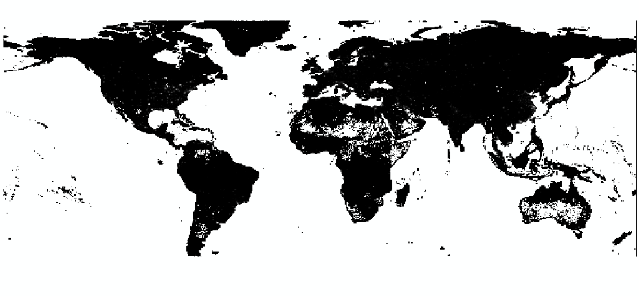 灯光遥感2024年1月全球拼接结果
代码如下:
import os
import glob
import h5py
import numpy as np
from osgeo import gdal, osr
import rasterio
from rasterio.merge import merge
from rasterio.warp import reproject, Resampling, calculate_default_transform
import tempfiledef resample_raster(input_path, output_path, target_resolution=0.5):"""重采样栅格数据并正确处理无效值"""with rasterio.open(input_path) as src:# 读取原始nodata值(如果没有则使用65535)src_nodata = 65535# 计算目标transform和尺寸dst_crs = src.crs  # 保持原坐标系transform, width, height = calculate_default_transform(src.crs, dst_crs, src.width, src.height, *src.bounds, resolution=(target_resolution, target_resolution))# 设置输出metadatadst_meta = src.meta.copy()dst_meta.update({'transform': transform,'width': width,'height': height,'nodata': src_nodata  # 保持一致的nodata值})# 执行重采样(自动排除无效值)with rasterio.open(output_path, 'w', **dst_meta) as dst:for i in range(1, src.count + 1):# 方法1:使用rasterio的自动nodata处理reproject(source=rasterio.band(src, i),destination=rasterio.band(dst, i),src_transform=src.transform,src_crs=src.crs,dst_transform=transform,dst_crs=dst_crs,resampling=Resampling.average,src_nodata=src_nodata,  # 关键:指定源无效值dst_nodata=src_nodata   # 保持输出无效值一致)def process_viirs_to_global_tiff(input_folder, output_path, target_resolution=0.5):"""处理VIIRS数据并直接重采样到指定分辨率"""# 获取所有h5文件h5_files = glob.glob(os.path.join(input_folder, '*.h5'))# 临时存储所有分块GeoTIFFtemp_files = []# 处理每个h5文件for h5_file in h5_files:try:with h5py.File(h5_file, 'r') as f:# 读取数据data = f['HDFEOS/GRIDS/VIIRS_Grid_DNB_2d/Data Fields/AllAngle_Composite_Snow_Free'][:]lon = f['HDFEOS/GRIDS/VIIRS_Grid_DNB_2d/Data Fields/lon'][:]lat = f['HDFEOS/GRIDS/VIIRS_Grid_DNB_2d/Data Fields/lat'][:]# data[data == 65535] = np.nan    # 将无效值设为NaN# 创建临时GeoTIFFtemp_file = tempfile.NamedTemporaryFile(suffix='.tif', delete=False).nametemp_files.append(temp_file)# 获取数据维度rows, cols = data.shape# 创建输出GeoTIFFdriver = gdal.GetDriverByName('GTiff')out_ds = driver.Create(temp_file, cols, rows, 1, gdal.GDT_Float32)# 设置地理参考信息(使用正弦投影)srs = osr.SpatialReference()srs.ImportFromEPSG(4326)# srs.ImportFromProj4("+proj=sinu +lon_0=0 +x_0=0 +y_0=0 +a=6371007.181 +b=6371007.181 +units=m +no_defs")out_ds.SetProjection(srs.ExportToWkt())# 计算地理变换min_lon, max_lon = np.min(lon), np.max(lon)min_lat, max_lat = np.min(lat), np.max(lat)pixel_width = (max_lon - min_lon) / colspixel_height = (max_lat - min_lat) / rowsgeo_transform = (min_lon, pixel_width, 0, max_lat, 0, -pixel_height)out_ds.SetGeoTransform(geo_transform)# 写入数据out_band = out_ds.GetRasterBand(1)out_band.WriteArray(data)out_band.FlushCache()# out_band.SetNoDataValue(-9999)out_ds = None  # 关闭文件except Exception as e:print(f"处理文件 {h5_file} 时出错: {str(e)}")continue# 合并所有临时GeoTIFFif temp_files:try:# 创建临时合并文件merged_temp = tempfile.NamedTemporaryFile(suffix='.tif', delete=False).name# 打开所有临时文件src_files_to_mosaic = []for file in temp_files:src = rasterio.open(file)src_files_to_mosaic.append(src)# 合并mosaic, out_trans = merge(src_files_to_mosaic)# 写入临时合并文件out_meta = src_files_to_mosaic[0].meta.copy()out_meta.update({"driver": "GTiff","height": mosaic.shape[1],"width": mosaic.shape[2],"transform": out_trans})with rasterio.open(merged_temp, "w", **out_meta) as dest:dest.write(mosaic)# 对合并后的文件进行重采样resample_raster(merged_temp, output_path, target_resolution)print(f"成功创建并重采样全球TIFF文件: {output_path}")except Exception as e:print(f"合并或重采样文件时出错: {str(e)}")finally:# 关闭所有文件并清理临时文件for src in src_files_to_mosaic:src.close()for file in temp_files + [merged_temp]:try:os.remove(file)except:passelse:print("没有有效的HDF5文件处理完成")# 使用示例
input_folder = r"E:\DBN_data\VNP46A3\2024\001"
day = int(input_folder[-3:])
output_tiff = os.path.join(input_folder, 'DNB_merge_'+str(input_folder[-8:-4])+str(day).zfill(2)+'_05deg.tif')
process_viirs_to_global_tiff(input_folder, output_tiff, target_resolution=0.5)
其中用的较多的,rasterio库,这个库我自己确实不知道这么多用处,感谢AI,让我学到了新东西。